1. Objectives
The Arktalas Hoavva project targets the following 7 interlinked specific objectives:
- OBJ-1: Define and implement scientific analysis, with a focus on synergy application building on a multi-modal data-driven analyses framework whereby coarse- and highresolution satellite data taking benefit of native resolution measurements of (i.e. single image snapshots, altimeter transects, etc..) will be combined and merged with available insitu data and model-based fields.
- OBJ-2: Develop and generate a multi-mission database of satellite, model outputs and insitu measurements. Data for the Arctic Ocean over a period of at least 10+ year including the 2018/19 season will be shaping this database and include the implementation of a data access system and data visualisation and scientific analysis tool.
- OBJ-3: Implement at least 6 science cases addressing the Arktalas Science and Society Challenges (ref. Section 1.5 of the SoW). The achievements associated with OBJ-2 will be essential for the selection and execution of the science cases. Following the approach detailed in OBJ-1 these case studies will also reveal limitation in the observing system and open up for consideration of provision of new data from future mission (OBJ-4).
- OBJ-4: Analyse the impact of planned future missions on Arktalas Science Challenges (set out in section 1.5) and knowledge with a focus on their likely scientific and societal impacts and contribution to synergic application of EO data sets.
- OBJ-5: Prepare and submit scientific journal articles reporting the scientific outcomes of the Arktalas study. Based on the scientific analyses undertaken to achieve OBJ-3 six manuscripts will be prepared and submitted.
- OBJ-6: Prepare a Scientific Roadmap of potential future activities and collaborations after 2020. This will capitalize on the outputs, lessons learned, knowledge, international collaboration, and tools developed. The Arktalas Scientific Roadmap (SR) will be written with identification of priority areas to be addressed in potential future activities (OBJ-4) in the Arctic Ocean;
- OBJ-7: Promote the Arktalas study and application of ESA satellite missions in the Arctic Ocean. The activities and findings shall be promoted using a range of multi-media events and tools (conferences, educational material, high quality plots, training courses, web site, web portal, reports) and via the organisation of an open scientific meeting located in a to be decided Arctic region.
2. Approach
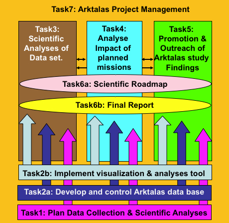
- Task 1- Lead NERSC:
Preparation and planning of the data collection and corresponding scientific analyses. This task is essential to ensure proper execution of the Arktalas Hoavva project, notably with respect to the implementation of the data collection and multi-modal data analyses framework that shall target research in relation to the 4 major Arctic science challenges. As such the delivery of the plan (D-10: TN-1) comes already after KO-3 months. The first iteration of this plan is further addressed in Section 1.
- Task 2a - Lead NERSC:
Arktalas Hoavva data collection and quality control. The Arktalas Data Archive System (ADAS) will be distributed and store priority satellite data and other complementary data sets including in-situ data and model fields covering areas north of 50 N as identified in Task 1. It will capitalize on existing data repositories residing among the partners. The ADAS will provide a means to search and retrieve data according to user queries. L2/L3 datasets required for the scientific analysis in Task 3 will be generated by the consortium starting from ADAS L1 data as part of this data collection effort. This includes sea ice drift and deformation from specific image sequences and wave retrievals from Sentinel-1 and CFOSAT in and across the MIZ. Moreover, it will be highly important to identify interoperability and possible solutions that can capitalize on the Data and Information Access Services (DIAS) that is funded by EU under the Copernicus program. DIAS allows the users to develop and host their own applications in the cloud, while removing the need to download bulky files from several access points and process them locally. The deliverable D-20: TN-2 will specify the design of the ADAS. It will be presented at the PM-2 (KO+6 months).
- Task 2b - Lead ODL:
Implementation of analyses and visualization system. The Analyses and Visualization System (AVS) will be based on the SynTool software, a Web portal developed by ODL for the interactive visualisation of satellite data, in-situ data and numerical simulation results. The SynTool software suite contains processing tools to extract time and space coverage from the raw data files and generate graphical representations for them while preserving their native geometry and resolution. Time and space coverages are then registered in a database that the Web portal can query to facilitate exploration by letting users know when and where data are available. It also includes a colocation tool that will help researchers during studies that involve several products. A preliminary version of the (AVS) has been created at ODL and NERSC. It builds on the OVL-GlobCurrent visualization portals and offer a Polar-stereographic projection for the pan-Arctic domain (>55 N). The AVS will be connected to the Arktalas Data Archive System (ADAS) and allow users to access and make use of the Arktalas dataset during the project. The design of the AVS will be included in a technical note (D-40: TN-3) to be delivered at PM-2 (KO+6 months). Moreover, following the acceptance of D-20 and D-40, user guides and QC results reports for both ADAS and AVS will be delivered (D-30 and D-60) followed by a verification report for the ADAS and AVS implementations to be delivered at PM-3 (KO+9 months).
- Task 3 - Lead Ifremer:
Scientific analyses of the Arktalas Hoavva data set. Using ADAS and AVS the execution of this task will cover the delivery of 6 scientific papers (D-70, D-80, D-90, D-100, D-110 and D-120) with focus on the 4 major Arktalas Hoavva scientific challenges, notably how EO may contribute to better:
-
- Characterize Arctic Amplification and its impact (ASC-1)?
- Characterize the impact of more persistent and larger area open water on sea ice dynamics (ASC-2)?
- Understand, characterize and predict the impact of extreme event storms in sea-ice formation (ASC-3)?
- Understand, characterize and predict the Arctic ocean spin-up (ASC-4)?
- In closing each of these papers will include an outlook with respect to future approved and planned missions. This will give important input to Task 4. In addition, societal impacts will be considered, discussed and reported in this Task 3.
- Task 4 - Lead Noveltis:
Analyses of future satellite mission impacts in understanding the change to the Arctic Ocean. Input from Task 3 will be important in order to assess the potential new observation capabilities of the high latitude seas and Arctic Ocean from the approved and planned satellite missions including, for instance, Copernicus candidate missions, ESA missions, third party missions. The results from this task be documented in a 7th scientific paper (D-130).
- Task 5 - Lead NERSC:
Promotion of the Arktalas Hoavva study and scientific community outreach. Both the ADAS and AVS together with the key findings and results will be open and freely available building on the open science approach. The Task will also aim to establish partnership with other projects and teams such as the EU Arctic research cluster allowing for discussion of relevant complementary topics and abilities to outline synergetic approaches of mutual benefits. Moreover, communication with the 4 invited international recognized experts in high latitude and Arctic Ocean research will both strengthen and promote the project. The deliverable from this task includes the Arktalas Web site (SW- 10), the Arktalas Web stories (D-140) and the Arktalas Scientific Review Proceedings (D-150). Education and training material will also be produced for specific use at the regular ESA ocean training courses.
- Task 6a - Lead Ifremer:
Creating a scientific roadmap. The major findings and results gained from this project study will lead to new questions and identification of new or refined challenges. These will be addressed in the scientific roadmap, and lead to a recommendation of priority activities for future research of the Arctic Ocean and surrounding seas. A dedicated Arktalas Scientific Roadmap (D-160) will be delivered 4 weeks prior to the final meeting.
- Task 6b - Lead NERSC:
Final report. The project activities and major results will be highlighted in the Arktalas final report (D-170) with an appendment containing the 7 scientific journal papers. This report will also be delivered 4 weeks prior to the final meeting. At the final meeting (KO+24 months) the Technical Data Package (TDP) that contains all the final versions of all the approved technical documents will also be delivered.
- Task 7 - Lead NERSC:
Arktalas Hoavva Project Management. The management of the project will ensure that the work breakdown is properly implemented and maintained, and that all the partners complies with their respective responsibilities and contributions. The management will also ensure proper communication, scheduling and reporting with the agency, as well as, if encountered, timely notification of problems. The contract closure documentation (CCD), structured according to Annex A in the Statement of Work, will also be delivered at the end of the project (KO + 24 months).
3. Timeline and Milestones (M1-M6).
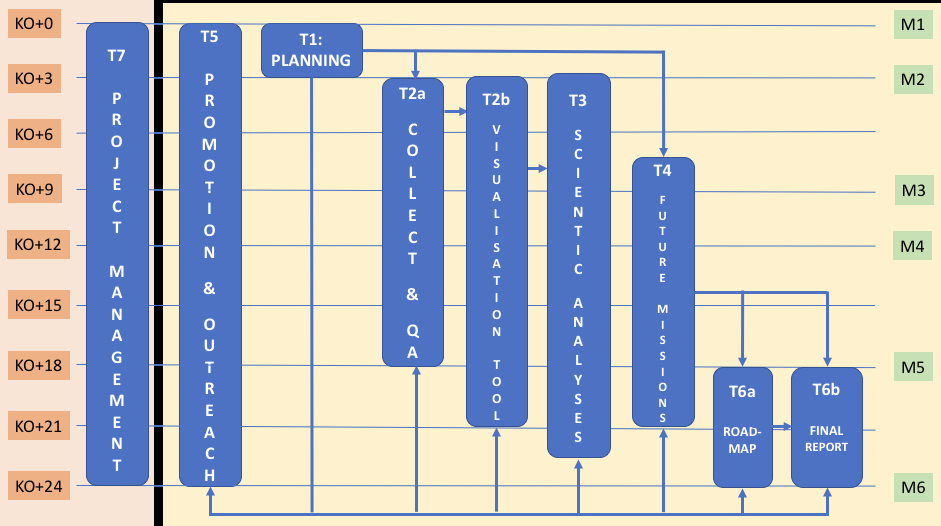
Note that the project Kick-Off took place on 9 July 2019.